A coastal flood warning runs 4 to 11 a.m. Sunday, with the harbor forecast at 8 feet. NOAA forecasts 8.1 feet Monday and Tuesday mornings, major flood stage.
The National Weather Service in Charleston has issued a coastal flood warning for Charleston County from 4 to 11 a.m. Sunday. The harbor is forecast to reach 7.9 to 8.1 feet at the morning high tide, around 7:34 a.m. Major flooding starts at 8 feet.
The worst may still be ahead. The weather service said its confidence is growing that Charleston will pass major flood stage on the Monday, Tuesday and Wednesday morning tides.
The warning, issued at 9:42 p.m. Saturday, expects one to two feet of water above ground along the shoreline and tidal creeks. It said “significant saltwater inundation will render numerous roads impassable” and that properties may flood. Water can be on the streets one to two hours before and after high tide.
The tide forecast, Sunday to Tuesday
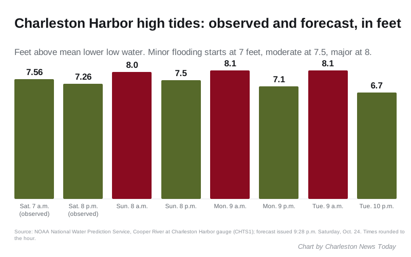
NOAA’s forecast for the Cooper River at Charleston Harbor gauge was issued at 9:28 p.m. Saturday. It gives these high tides:
| High tide | Forecast | Flood stage |
|---|---|---|
| About 8 a.m. Sunday | 8.0 feet | Major |
| About 8 p.m. Sunday | 7.5 feet | Moderate |
| About 9 a.m. Monday | 8.1 feet | Major |
| About 9 p.m. Monday | 7.1 feet | Minor |
| About 9 a.m. Tuesday | 8.1 feet | Major |
| About 10 p.m. Tuesday | 6.7 feet | Action stage, below flooding |
Heights are in feet above mean lower low water. Times come from the hourly forecast and are rounded to the hour; the warning puts Sunday’s high tide at 7:34 a.m.
The gauge has already flooded on four straight tides. It reached 7.56 feet at 7:18 a.m. Saturday, moderate flood stage, and 7.26 feet at 7:36 p.m. Saturday. Friday’s two tides peaked at 7.06 and 7.02 feet.
Why the tides are this high
The weather service’s forecast discussion, issued at 9:49 p.m. Saturday, calls it “a significant, multi-day coastal flooding event.” It lasts through at least the middle of the week. Two things are stacking up:
- The year’s highest tides. The full moon is Monday, Oct. 26, and the moon is closest to Earth on Wednesday, Oct. 28.
- Strong northeast winds. They have been pushing water toward the coast for days and are forecast to keep blowing into early next week.
The weather service said flooding will likely come with both daily high tides for several days, with the evening tide the lower of the two. It said more advisories will definitely be needed. Coastal flood watches or warnings are “very likely” for some or all of the coast from Sunday through Wednesday.
Which streets flood at these levels
The weather service lists what usually happens at each level on the gauge page:
- 7 feet, minor. Water on Lockwood Drive, Wentworth and Barre streets, Fishburne Street and Hagood Avenue, and Morrison Drive. Low spots on Isle of Palms, Sullivan’s Island, Folly Beach, Kiawah Island and Edisto Island also flood.
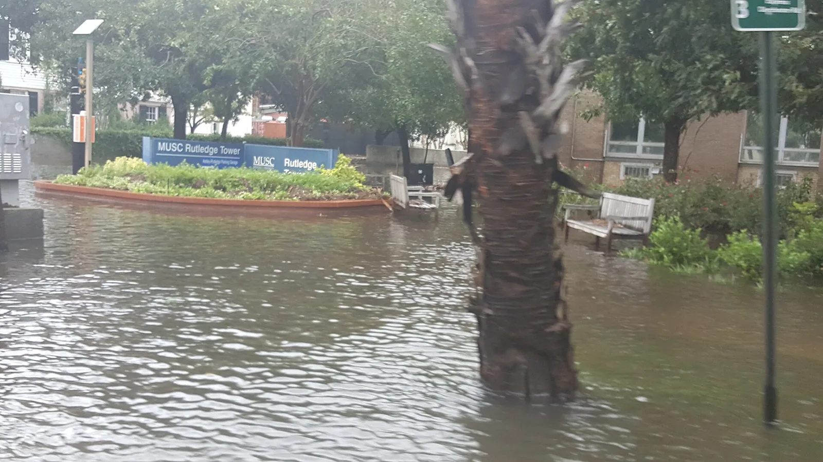
- 7.5 feet, moderate. More downtown roads, including U.S. 17 at S.C. 61, Market Street, East Bay Street, Rutledge Avenue and the streets around MUSC. Long Point Road in Mount Pleasant, about six miles northeast, can flood too.
- 8 feet, major. Widespread flooding downtown. Many roads become impassable and some water reaches buildings.
Surf and rip currents
The same warning covers the beaches. A high surf advisory for Charleston and coastal Colleton counties runs until 5 p.m. Monday, with breaking waves of 4 to 6 feet. The rip current risk is high through Sunday evening, and the weather service expects beach erosion around high tide.
Rain is not part of the threat. The weather service expects dry weather and below-normal temperatures into early next week.
What it means for you
- Stay off low downtown streets from about 5:30 to 9:30 a.m. Sunday. That is the window the warning gives around the 7:34 a.m. high tide. Plan the same for Monday and Tuesday mornings, about an hour later each day.
- Move your car if it is parked on a street that floods. Do it the night before a morning tide.
- Never drive around a barricade or into water. City law bans driving faster than 5 mph on a street with 6 or more inches of water, and the city has said the Charleston Police Department can ticket drivers who go around barricades.
- Check live closures on the city’s WaterWise page and the TIDEeye app before you set off.
- Stay out of the surf unless you are a strong swimmer near a lifeguard.
- Report a flooded street to the city’s Citizen Services Desk at 843-724-7311.
The city had posted no storm parking or closure notice for this weekend as of late Saturday. We will update this story when it does, and when the weather service extends its warning to Monday’s tide.
This follows our weekend tide forecast. See also our road closures page, getting around and hurricane and flood prep.
Frequently asked questions
When is the coastal flood warning for Charleston?
The National Weather Service in Charleston issued a coastal flood warning for Charleston County from 4 to 11 a.m. Sunday, Oct. 25. High tide is around 7:34 a.m., and saltwater flooding is possible one to two hours either side of it.
How high will the tide get in Charleston this week?
NOAA’s forecast issued Saturday night puts Charleston Harbor at 8 feet around 8 a.m. Sunday and 8.1 feet around 9 a.m. Monday and Tuesday. Major flooding starts at 8 feet.
Which Charleston streets flood at 8 feet?
At 7.5 feet the weather service lists U.S. 17 at S.C. 61, Market Street, East Bay Street, Rutledge Avenue and the streets around MUSC. At 8 feet it expects widespread downtown flooding, with many roads impassable and some water reaching buildings.
Have your say