A coastal flood warning is in effect 4 to 11 a.m. Sunday, with Charleston Harbor forecast at 8 feet, major flood stage. Monday and Tuesday mornings are forecast at 8.1 feet.
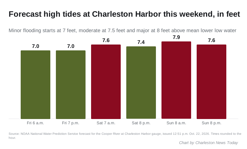
High tides are forecast to flood low streets in downtown Charleston from Friday into next week. The worst so far is Sunday morning. The harbor is forecast to reach 7.9 feet around 8 a.m. Sunday, which is moderate flood stage.
Updated Oct. 25: The National Weather Service issued a coastal flood warning for 4 to 11 a.m. Sunday, with the harbor now forecast at 7.9 to 8.1 feet, major flood stage. NOAA forecasts 8.1 feet around 9 a.m. Monday and Tuesday. The gauge reached 7.56 feet Saturday morning. Read the flood warning and the new forecast.
That figure comes from the NOAA forecast for the Cooper River at Charleston Harbor gauge, issued at 12:51 p.m. Thursday. The gauge read 4.55 feet at 2:30 p.m.
The National Weather Service in Charleston expects a multi-day coastal flooding event. Its forecast discussion issued at 2:20 p.m. Thursday gives two reasons:
- Strong northeast winds. High pressure over New England and the Mid-Atlantic states will push water toward the coast through the weekend and into early next week.
- The year’s biggest tides. A full moon Monday, Oct. 26, and the moon’s closest approach on Wednesday, Oct. 28, raise the tides on their own.
The weather service said the highest astronomical tides of 2026 come Tuesday and Wednesday. Charleston Harbor then peaks at about 6.9 feet before any wind is added. It said the chance of moderate or even major flooding at the harbor will grow over the weekend and into next week.
No coastal flood advisory or warning was in effect for Charleston County as of Thursday afternoon. The weather service issues those closer to each high tide.
The tide forecast, high by high
| High tide | Forecast | Flood stage |
|---|---|---|
| About 6 p.m. Thursday | 6.9 feet | Action stage, below flooding |
| About 6 a.m. Friday | 7.0 feet | Minor |
| About 7 p.m. Friday | 7.0 feet | Minor |
| About 7 a.m. Saturday | 7.6 feet | Moderate |
| About 8 p.m. Saturday | 7.4 feet | Minor |
| About 8 a.m. Sunday | 7.9 feet | Moderate |
| About 8 p.m. Sunday | 7.6 feet | Moderate |
Heights are in feet above mean lower low water, the datum NOAA uses for this gauge. Times come from the hourly forecast and are rounded to the hour. The forecast does not yet reach Tuesday’s and Wednesday’s tides.
Which streets flood at these levels
The weather service publishes what usually happens at each level on the gauge page:
- 7 feet, minor flooding. Water on roads around downtown, possibly Lockwood Drive, Wentworth and Barre streets, Fishburne Street and Hagood Avenue, and Morrison Drive. As the tide nears 7.5 feet, roads can become impassable and close. Low spots near the beaches on Isle of Palms, Sullivan’s Island, Folly Beach, Kiawah Island and Edisto Island also flood.
- 7.5 feet, moderate flooding. More downtown roads, including U.S. 17 at S.C. 61, Market Street, East Bay Street, Rutledge Avenue and the streets around MUSC. Long Point Road near Palmetto Islands County Park in Mount Pleasant, about six miles northeast, can also flood.
- 8 feet, major flooding. Widespread flooding downtown, with many roads impassable and some water reaching buildings.
The weather service said the morning high tide will be the bigger of the two each day.
Rough surf and rip currents too
The same winds bring trouble at the beaches. The weather service said rip current risk rises over the weekend, with high surf of 5 feet or more possible. It expects beach erosion around each high tide. Gales are likely offshore from Saturday, and a small craft advisory will probably be needed for Charleston Harbor.
The weekend itself should be dry. The weather service forecasts sunshine with highs in the lower to mid 70s and no rain into early next week.
What it means for you
- Plan downtown trips around the morning high tides. Saturday about 7 a.m. and Sunday about 8 a.m. are the forecast peaks.
- Check before you drive. The city’s WaterWise page and the TIDEeye app show flooded streets in real time.
- Never drive around a barricade or into standing water. City law bans driving faster than 5 mph on a street with 6 or more inches of water.
- Move a car parked on a low street before a morning high tide, especially near Lockwood Drive, Hagood Avenue, Market Street and MUSC.
- Report a flooded street to the city’s Citizen Services Desk at 843-724-7311.
We will update this story when the weather service issues an advisory or when the city announces closures or storm parking. See our road closures page, getting around and hurricane and flood prep guides.
Frequently asked questions
When will downtown Charleston flood this weekend?
The morning high tides are the ones to watch. NOAA forecasts 7.6 feet at Charleston Harbor about 7 a.m. Saturday and 7.9 feet about 8 a.m. Sunday, both in the moderate flood range. Sunday evening’s tide, about 8 p.m., is forecast at 7.6 feet.
What tide level floods Charleston streets?
The National Weather Service counts 7 feet above mean lower low water at the Charleston Harbor gauge as minor flooding, 7.5 feet as moderate and 8 feet as major. At 7 feet, roads such as Lockwood Drive, Wentworth and Barre streets, Fishburne Street and Hagood Avenue, and Morrison Drive can take water.
When are the highest tides of 2026 in Charleston?
The National Weather Service in Charleston said the highest astronomical tides of 2026 come Tuesday, Oct. 27, and Wednesday, Oct. 28, when the harbor peaks at about 6.9 feet before any wind effect.
Have your say