Eight Charleston areas, from downtown and West Ashley to James Island, Johns Island, Daniel Island and Cainhoy: zoned high school and home value.
Last checked Oct. 16, 2026. Sources: the City of Charleston’s Charleston City Plan and GIS map service, OpenStreetMap, Charleston County School District’s school lookup tool, Berkeley County’s school attendance zones, the South Carolina school report cards, the U.S. Census Bureau and Zillow Research.
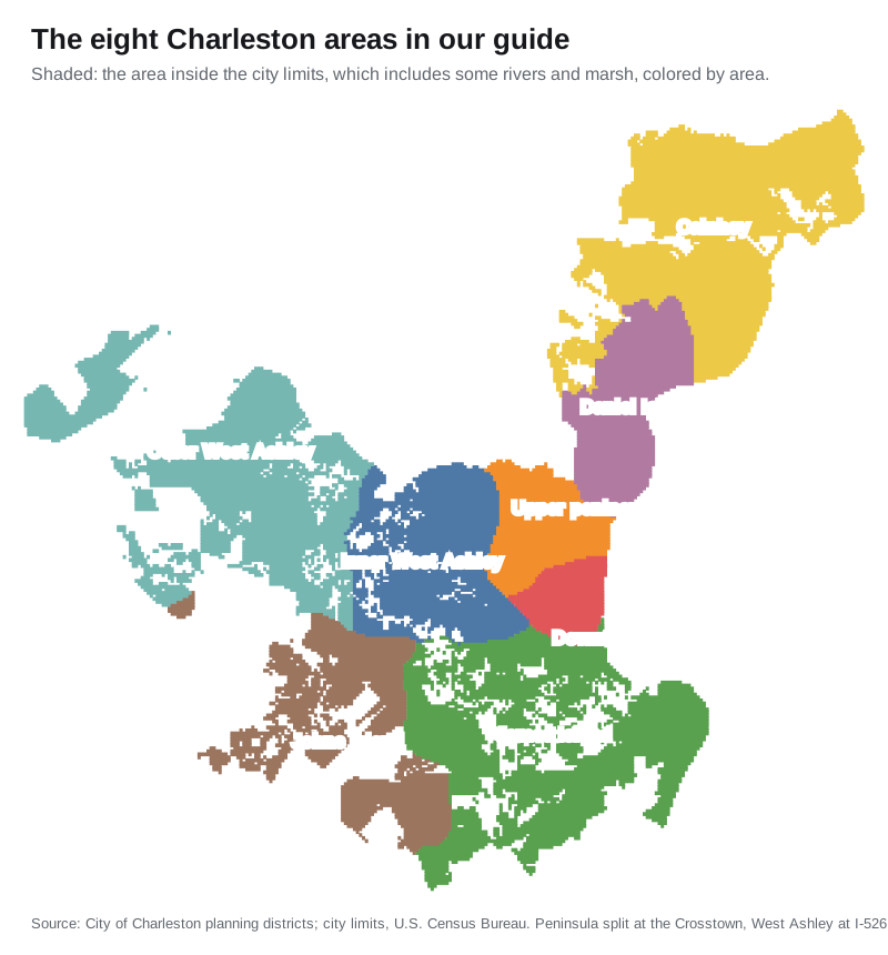
Charleston has about 154,338 residents, according to the Census Bureau’s 2020-2024 American Community Survey on its QuickFacts page. The city is spread across a peninsula and several islands, joined by bridges over the Ashley, Cooper, Wando and Stono rivers. This guide splits it into eight areas that the city’s own City Plan and planning maps name, and gives each one its schools, home values, parks and commute.
What this means for you
- The county decides the school district: the peninsula, West Ashley, James Island and Johns Island are in Charleston County and Charleston County School District; Daniel Island and Cainhoy are in Berkeley County and Berkeley County School District. Check an address with the CCSD lookup or Berkeley County School District.
- City limits are patchy: West Ashley, James Island, Johns Island and Cainhoy all mix city and county land. Check a parcel on Charleston County’s GIS Parcel Viewer.
- Home values by ZIP code: from $467,761 in 29414 to $1,526,329 in 29401 in September 2026, according to the Zillow Home Value Index.
How the city is laid out
- Six planning districts. The city’s GIS maps six: the Peninsula, West Ashley, James Island, Johns Island, Daniel Island and Cainhoy. The City Plan groups Daniel Island and Cainhoy as the “Cainhoy Peninsula.” We split the peninsula at the Crosstown (U.S. 17) and West Ashley at I-526, which the plan uses to separate West Ashley’s older neighborhoods from its “new subdivisions west of I-526.”
- Roads. I-26 runs down the peninsula to downtown, and I-526 loops from West Ashley through North Charleston to Daniel Island and Mount Pleasant. U.S. 17 crosses the Ashley River to West Ashley and the Ravenel Bridge to Mount Pleasant. James Island and Johns Island have no interstate. More in our getting around guide.
- ZIP codes do not follow neighborhoods, and several cover land outside the city.
- School zones do not follow city limits. Each county’s district assigns schools by address.
- Neighborhood associations. The city’s neighborhood council map lists about 120 registered associations; each area page names the ones inside it.
The areas at a glance
| Area | Main ZIP code | Zoned high school | Home value, Sept. 2026 | Guide |
|---|---|---|---|---|
| Downtown | 29401 | Burke High | $1,526,329 | Downtown |
| Upper peninsula | 29403 | Burke High | $855,456 | Upper peninsula |
| Inner West Ashley | 29407 | West Ashley High | $526,393 | Inner West Ashley |
| Outer West Ashley | 29414 | West Ashley High | $467,761 | Outer West Ashley |
| James Island | 29412 | James Island Charter High | $593,604 | James Island |
| Johns Island | 29455 | St. John’s High | $746,511 | Johns Island |
| Daniel Island | 29492 | Philip Simmons High | $981,837 | Daniel Island |
| Cainhoy | 29492 | Philip Simmons High | $981,837 | Cainhoy |
Home values are the Zillow Home Value Index for the main ZIP code, a modeled typical value for the middle third of homes, not a sale price. Zillow’s figure for the city as a whole was $587,511. Daniel Island and Cainhoy share ZIP code 29492. More in our home prices guide and schools guide.
Downtown
The lower peninsula south of the Crosstown, with Harleston Village, Charlestowne (south of Broad Street), Ansonborough, the French Quarter and Radcliffeborough. About 44% of it is in the city’s Old and Historic District. Zoned for Memminger or Sanders-Clyde elementary, Simmons-Pinckney Middle and Burke High. Downtown guide.
Upper peninsula
North of the Crosstown to the North Charleston line: Hampton Park Terrace, Wagener Terrace, the Westside, North Central, Rosemont and the Neck, with Hampton Park and The Citadel. The city’s Upper Peninsula Zoning District covers the commercial land east of I-26. Mostly zoned for Sanders-Clyde Elementary and Burke High. Upper peninsula guide.
Inner West Ashley
West Ashley east of I-526: Avondale, Byrnes Downs, the Windermere neighborhoods, Moreland and the Sam Rittenberg Boulevard and Savannah Highway corridors, with Charles Towne Landing. Nearly all ZIP code 29407 and zoned for West Ashley High. Inner West Ashley guide.
Outer West Ashley
West of I-526 along Glenn McConnell Parkway, Bees Ferry Road and Ashley River Road: Shadowmoss, Village Green, Hickory Hill and other newer neighborhoods, where the City Plan says most new West Ashley development is happening. Zoned for Drayton Hall, Oakland or Springfield elementary and West Ashley High. Outer West Ashley guide.
James Island
The city’s part of James Island, mixed with the Town of James Island and county land, along Folly Road, Maybank Highway and Fort Johnson Road. The City Plan says it has the city’s highest share of parks and its slowest growth. Zoned for James Island Charter High. James Island guide.
Johns Island
The city’s land along Maybank Highway and River Road, the fastest-growing part of the city in the City Plan’s 2010-2019 estimates. Home to the Angel Oak. Zoned for St. John’s High. Johns Island guide.
Daniel Island
A planned community annexed in the 1990s, in Berkeley County, with its own town center and I-526 exit. Zoned for Daniel Island School and Philip Simmons High. Daniel Island guide.
Cainhoy
The city’s land along Clements Ferry Road north of Daniel Island, in Berkeley County, with the city’s lowest population density. Zoned for the Philip Simmons elementary, middle and high schools. Cainhoy guide.
How we built this
- The areas are the city’s six planning districts from its GIS map service and the City Plan, adopted Oct. 12, 2021, which also uses “Upper Peninsula” and maps inner and outer West Ashley separately. The lines we drew inside two districts, the Crosstown and I-526, are ours. We kept only land inside the city limits, from the Census Bureau.
- Neighborhood names come from the city’s neighborhood council map and from place names mapped on OpenStreetMap, such as South of Broad, Wagener Terrace and Avondale. The roughly 120 registered associations are named on the area pages; they do not have pages of their own.
- Schools: we tested a grid of points about a tenth of a mile apart in each area, 414 to 2,868 points per area, against Charleston County School District’s attendance boundaries in its school lookup tool and Berkeley County’s 2026-27 school zones, and give the share of points zoned for each school. Ratings are from the state’s 2025 report cards.
- Distances: measured on the OpenStreetMap road network from a named park or school in each area; they are distances, not drive times. Exit numbers are as mapped on OpenStreetMap. Bus routes are from CARTA’s schedule data.
- Home values: the Zillow Home Value Index, September 2026.
- Map: planning districts from the City of Charleston; city limits from the U.S. Census Bureau’s TIGERweb.
Comparing whole cities? See Charleston vs Hanahan vs North Charleston vs Goose Creek.
Frequently asked questions
What are the main areas of Charleston, South Carolina?
The city’s City Plan divides Charleston into the peninsula, West Ashley, James Island, Johns Island and the Cainhoy peninsula, which includes Daniel Island. Our guide covers eight areas: downtown, the upper peninsula, inner and outer West Ashley, James Island, Johns Island, Daniel Island and Cainhoy.
What school district is Charleston in?
It depends on the county. The Charleston County parts of the city, the peninsula, West Ashley, James Island and Johns Island, are served by Charleston County School District. Daniel Island and Cainhoy are in Berkeley County and are served by Berkeley County School District.
What ZIP codes are in Charleston?
The main City of Charleston ZIP codes are 29401 and 29403 on the peninsula, 29407 and 29414 in West Ashley, 29412 on James Island, 29455 on Johns Island and 29492 on Daniel Island and Cainhoy. In September 2026 the Zillow Home Value Index ranged from $467,761 in 29414 to $1,526,329 in 29401.
Which part of Charleston has the most people?
West Ashley. The City Plan estimated 66,992 people in its West Ashley planning area in 2019, against 40,969 on the peninsula, 22,215 on James Island, 15,399 on the Cainhoy peninsula and 10,961 on Johns Island. Those areas include some land outside the city.
Have your say